Author: dougrm

  • Archiving Scotland’s rock art for the future

    Archiving Scotland’s rock art for the future

    Over the past four years Scotland’s Rock Art Project (ScRAP) has generated a large volume of digital data through field recording and 3D modelling of rock art. The data, co-created by the project team and trained community teams, has greatly improved our knowledge of Neolithic rock art in Scotland. The project team have used the data to contribute to academic journals, as well as a new& publication scheduled for 2023. On top of this ScRAP aims to preserve and share the data, to promote future research and public awareness.

    I joined ScRAP as a digital archivist in April 2021. My background is in archives management and digital preservation, having worked for both the National Library of Scotland and Historic Environment Scotland (HES). My goal is to scope the ScRAP data to be archived, identify appropriate metadata standards, and communicate with different archive stakeholders. Following this I will archive the dataset in the HES digital repository, with a secondary deposit at the University of Edinburgh’s DataShare.

    The Rock Art Bute team at work at Glenvoidean 19. DP 354787

    My goal is to ensure that the data are archived to a high standard. I evaluate this using FAIR principles, alongside other international standards. FAIR principles (Findable, Accessible, Interoperable, Re-usable) establish a foundation for good data preservation. I am grateful to Peter McKeague who has evaluated FAIR principles against the HES digital repository and its public access website, Canmore. On top of this I have developed a metadata standard that draws from General International Standard Archival Description and HES digital archive cataloguing policies. I also reviewed best practice guidance for archiving 3D photogrammetry developed by Archaeological Data Service, HES, Historic England, and the Royal Commission for Archaeological and Historical Monuments in Wales.

    ScRAP’s digital archive includes: 3D models, as well as raw photographs and model screenshots; contextual photographs taken during fieldwork; location and panel sketches. These primary data will be archived alongside fieldwork descriptions for each rock art panel, both of which will be put into Scotland’s National Record for the Historic Environment. This record can be accessed through the public website Canmore

    A sketch of Prieston 3. SC 2174085

    Cataloguing records is a time-consuming process. On an average day I will review a set of data, identify suitable records for long-term retention, ingest these records into our long-term preservation system, and assign appropriate metadata. I have automated this process where possible, which allows me to focus on more complicated panel records. I also contribute to internal and external publicity regarding the ScRAP archive.

    I am currently processing records in alphabetical order by council area. At the end of July 2021 I had processed all the records from Argyll and Bute (over 300 panels!). This includes over 300 GB of data, comprising over 52,000 digital files.

    A snapshot of the 3D model for Blairbuy 3. DP 361475

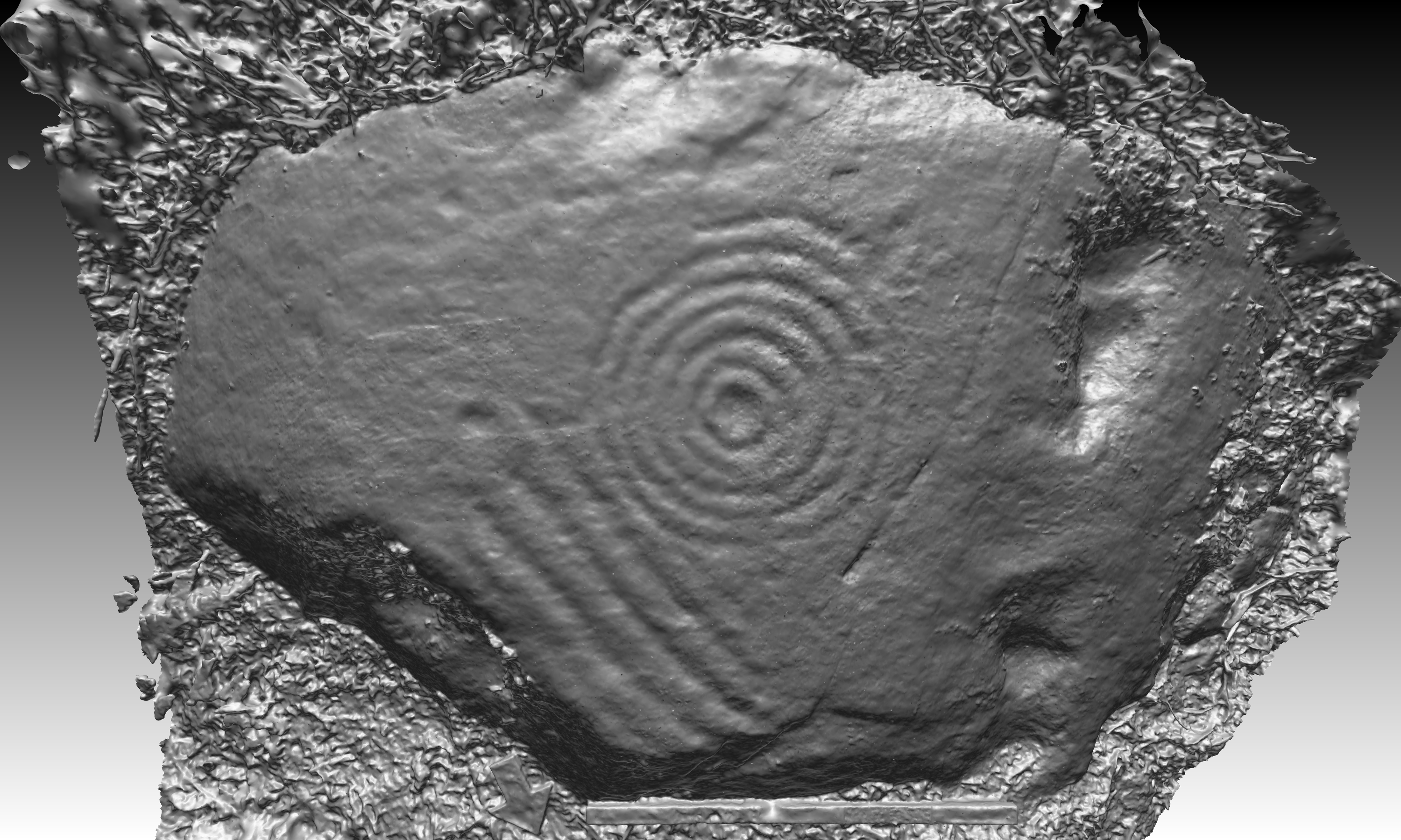
    You can view data in the HES Digital Archive through the Canmore website. Through Canmore you can navigate the catalogue hierarchy, or search for individual rock art panels. Most of these panels have been linked to site records in our GIS database, giving a more comprehensive overview of the national record for these archaeological monuments. You can view digital images via Canmore and request higher resolution images, as well as 3D models and raw photogrammetry photographs, from our Public Services team. Any images or models you ask for will be provided free of charge.

    Until the end of the project in December& 2021 I will continue to archive fieldwork data gathered before September 2021. Following this I will deposit a secondary archive with all the data with the University of Edinburgh DataShare, as well as with appropriate HERs. Our current plans are to keep the ScRAP website and database as an online resource post-project for at least five years, but after September 2021 any new rock art data will be submitted directly to Canmore.

  • Shining new light on an ancient mystery with Nick Parish

    Shining new light on an ancient mystery with Nick Parish

    Community based groups and individuals spread across Scotland have been trained up to a level where they can independently record the sites in and around their local areas. Many of the volunteers also join in with fieldwork carried out by ScRAP’s Project Team on their visits to places where there are high concentrations of rock art. Some of the local teams comprise existing regional amateur archaeological societies and others have been formed from scratch by interested newcomers.

    I joined the project as a community volunteer in 2018 when I attended a training session held in Callander, the small town in the Loch Lomond and The Trossachs National Park where I live. I’ve always had an interest in history and archaeology, seriously considering it as a degree option. My home county is Yorkshire, which has its own quite well-known petroglyph hotspots, such as Ilkley Moor, so I’ve had a loose knowledge and awareness of rock art for many years.

    Instead, I took a career path that led me briefly onto the oil rigs as a geologist before spending the next 20 years as a health physicist in the nuclear industry. It was this which brought me over the border to Scotland. Both my wife and I gave up our respective careers in our forties and decided to work for ourselves, a life-changing turn of direction we have never regretted. In the last three years or so I’ve gradually settled into semi-retirement and usually have time enough on my hands to indulge my own interests. In Scotland this usually means whenever the weather is half decent!

    Over Glenny 12, Stirlingshire, one of many carved rocks in the area where I did the ScRAP training in 2018

    After completing the ScRAP training, getting together the appropriate kit, and with the necessary apps on my phone, I was soon tramping about various highland backwaters locating and recording rock art sites. Mostly I work alone but occasionally join up with the Project Team when they come over my way. I’m very much an outdoors person and enjoy walking and off-road biking in the Scottish hills. Rock art recording fits in very nicely with this as a large percentage of the Scottish sites are in upland or out-of-the-way rural areas. Plus, there are literally hundreds of rock art sites to be visited and recorded in Stirlingshire and Perthshire, all within about an hour’s drive.

    I do quite a bit of background checking before I visit a site, all online. Some rocks can be quite difficult to reach, and then to find when you finally get there, so the ordnance survey map is the first point of call. I always check the geological map as well, as the geology is fundamental to understanding both the wider landscape and its more detailed features. Archaeological records and other references are accessed via Historic Environment Scotland’s Canmore and Pastmap websites (canmore.org.uk and pastmap.org.uk) and there some amateur antiquarian sites which can also supply useful information.

    Blarnaboard 1 in Perthshire was quite a challenge to record because there are several carved rock surfaces on this long stretch of bedrock

    Fieldwork involves taking measurements and photos, a precise GPS reading and recording specific attributes of the rock art, which are all entered on a standard form. I write a description and make sketches of the panel and carry out a risk assessment of various factors that could damage it. Very importantly, a series of overlapping photographs is taken which covers the whole surface of the panel.

    Back at home, I enter and upload all the information gathered in the field into the ScRAP database, and with specialised software then process the sequence of overlapping images to produce a digital 3D model of the panel. The end results of this are fascinating and allow the often eroded and obscure motifs to be viewed with far greater clarity, potentially revealing detailed features that can’t be seen in the field.

    My 3D model of part of a strange carved outcrop on the edge of Leckie Broch in Stirlingshire

    With so many choices of where to go next, and the chance of finding completely new sites, the whole process becomes mildly addictive. I find the fieldwork quite mindful and contemplative, especially as I’m more often than not alone in relatively remote and scenic places. After visiting a few rock art locations you soon see similarities between them and realise the people who created these markings had a deep connection with the landscape. You can’t help but reflect on why the carvings were made and what their meaning was. As you can imagine, theories abound, some grounded and others definitely straying into the realms of metaphysics. My own scientific background makes me uncomfortable with interpretations that are made speculatively without any real evidence to support them.

    Cloanlawers 6 is a really striking carved boulder on the slopes above Loch Tay in Perthshire. There are hundreds of carved panels in this area, and I recorded quite a few of them with Tertia from the ScRAP Project Team, and Andrew from the ScRAP Killin Team

    What has really struck me most about this type of rock art is not what it is, but what it’s not. Carved and painted rock art has been created in different parts of the world for at least 44,000 years. From the earliest times, humans have depicted themselves, animals and even weapons on natural rock surfaces, often to a high level of artistic quality and including some sort of narrative, such as a hunting scene.

    Yet in Britain’s Neolithic and Bronze ages this fundamental instinct to portray that animate world was precluded. So why the difference? To me this indicates that a system or discipline operated that had some sort of formality behind it. There is a ‘code’ locked away, and ScRAP’s data analysis might just possibly hold the key.

    Of course, the people who carved these rocks perceived the world in a very different way from us. The complexity and apparent randomness of their designs may ultimately shroud their meaning and the stones will be allowed to keep their secrets forever.

  • Discovering Rock Art with Douglas Ledingham

    Discovering Rock Art with Douglas Ledingham

    In mid-May 2020 during lockdown I was out on my bike with my wife searching for new trails close to home. On stopping to check the map I noticed a large moss-covered boulder that had unusual depressions on it. I thought it may have been cup marked, not because I had any expertise, but because I had seen cup marked rocks at Cairnbaan in Kilmartin many years ago. I reported the find to the East Lothian County Heritage Officer who in turn informed Dr Tertia Barnett from ScRAP of the suspected rock art.

    Discovering the Whitelaw Hill panel in May 2020 during lockdown, after it was exposed by felling of the adjacent woodland

    When Tertia was able to visit the Whitelaw Hill site some weeks later, I met her there and could tell that it was an important find as she seemed to be pretty elated! I learned that there are actually very few cup-marked rocks in East Lothian so this was indeed a rare find. The local tractor driver later told me that he had ploughed up the stone some 20 years previously but had not noticed the carvings and it had lain undisturbed at the side of a footpath since. I reported the find as Treasure Trove and hope the stone will end up in a museum for everyone’s enjoyment.

    Meeting Tertia for the first time at Whitelaw Hill when she was recording the panel. Removing the debris revealed the complex cup and ring motifs and unusually well-preserved tool marks

    After seeing how the stone was recorded by Tertia I realised that recording rock art hit many of my interests; map reading, GPS, computing, photography, research and being outdoors. I joined Scotland’s Rock Art Project and that set me off recording rock art and updating the ScRAP database. I visited several sites where rock art had previously been recorded and found nothing there, or just rocks with natural features. This did not deter me as I was happy to tidy up the database and to me a ‘hit’ was as good as a ‘miss’ if the records became more accurate. In addition to visiting sites on the database it seems like I now stop at every farmer’s rock pile and look at every stone in every dyke searching for undiscovered rock art. I have also found that many of the previously recorded rock art sites are not actually rock art at all but natural features in the rock that look like cup marks. It is surprising how many rocks in the Lammermuir Hills appear to be cup marked, and also how many fossilised ferns I have found in dykes!

    Recording a cup and ring marked rock at King’s Park, Stirling

    I was incredibly lucky to find another cup marked stone close to Soutra about two months after my first find. It was a small stone lying partially covered at the side of a field with a very clear cup and ring with peck marks. It is incredible to think that someone had carved it over 4000-5000 years ago. So that was another Treasure Trove report and two cup-marked stones added to the East Lothian inventory. That doesn’t seem like much but there are less than ten recorded in the county. I’m sure there are more to be found so I will keep looking! 

    My second discovery! A small cup and ring marked stone at Soutra Hill, East Lothian

    I have found that many of the rocks that I go to visit are no longer there. They have been lost, and one I searched for is now probably underneath a tennis court as back fill! Others are possibly lost to windfarm development. This loss of previously recorded stones concerns me as we really need to keep the few stones we have for future generations.

    The Scotland’s Rock Art Project has certainly kept my wife and I busy over the last few months; it has got us out to new places, learning new things, and I am pleased that what we are doing is adding to our national heritage. I have only been involved for a very short period of time and have lots to learn, but it has been a wonderful way to think about the people and the landscape that were here 4000-5000 years or so ago.

  • Rock Art: Data: Materials by Lucy Killoran

    Rock Art: Data: Materials by Lucy Killoran

    Lucy Killoran is a designer and researcher living in Glasgow. She has a BA from London College of Communication and an MFA from Edinburgh College of Art.

    Lucy’s MFA project used a period of archaeological fieldwork as subject matter to explore the transfer and re-materialisation of data through fabrication technologies. Her dissertation examined points of material crossover within the fields of art and archaeology.

    She currently works on a variety of freelance and self-initiated research projects whilst also pursuing an Erasmus+ Traineeship in the 3D digitisation of cultural heritage.

    I’m a designer interested in looking critically at materials, technology and interpretations of cultural heritage. I’ve just graduated from my MFA at Edinburgh College of Art where I was lucky enough to become involved with Scotland’s Rock Art Project—an experience which drove the direction of my research and my final project.

    image

    A machine-knitted piece from my graduate show.

    My main studio practice at ECA was based in textiles, but I also elected to take a portion of my credits in the archaeology department at Edinburgh University. I became involved with Scotland’s Rock Art Project through this elective study, attending the ScRAP Kilmartin field school in the summer of 2018. This was between the first and second years of my MFA, and it helped to give a live application to my research.

    image

    One of the rock art panels which my project focused on: Glasvaar 7, or “the whale” as it was dubbed by my fieldwork team

    ‘Textiles’ usually sparks thoughts of fashion or soft furnishings, which is not inaccurate, but casts a fairly narrow net over what can be a much more diverse subject. My approach to textiles is more focused on the physical materials, matter or substances which make up the world around us, and the cultural meanings ascribed to them (which I suppose explains my interest in archaeology too!).

    image

    Glasvaar 7 in the process of being cleaned.

    My MFA research led me to examine the use of digital technologies within cultural heritage; a fascinating area offering expanded opportunities for the dissemination and protection of cultural heritage, yet also presenting new issues such as the loss of ‘authenticity’ and tactility. I wanted to test these technological approaches for myself, combining them with my interest in materials and their meanings.

    image

    Using sight, touch (and of course, brightly coloured beads) to help locate motifs on a rock surface.

    Using data gathered on the ScRAP field school in Kilmartin, my final project contrasted the results of the re-materialisation of this data through technologies including 3D printing, CNC routing (a computer controlled cutting drill head), and digital machine knitting.

    image

    The CNC at work, cutting a test section of a 3D model in wood.

    Through these processes of fabrication, archaeological information is transferred into new materials. This conscious injection of information back into materials—a metaphorical reverse engineering of the archaeological process—aims to encourage new forms of engagement through unexpected material encounters.

    image

    A section of Glasvaar 7 being digitally prepared for the CNC

    The two main outputs of my project were CNC routed models and machine knitted textile objects. The CNC models created objective material reproductions which transport the surfaces of rock art panels to more accessible, but alien, locations. Their scale is reduced, but details remain accurate.

    image

    The result of the previous image: a section of Glasvaar 7 re-materialised as a CNC routed model

    The machine knitted objects distort the original data, but the sense of unfamiliar markings appearing in a familiar context mimics the experience of encountering rock art in the field—the carvings emerging from the rock surface as the eyes and hands learn to find them.

    image

    Another section of Glasvaar 7; this time the data was translated through hacked machine-knitting hardware.

    I’m continuing to work on the ScRAP project today, and after supervising a team on this year’s Kilmartin field school I’m now carrying out an initial analysis of all of the 3D models created on the project so far. I feel privileged to be able to methodologically examine and consider these new digital manifestations of rock art panels. I’m also about to start a two month Erasmus Traineeship at the Factum Foundation for Digital Technology in Conservation, where I will be learning more about 3D digitisation of cultural heritage and digital fabrication outputs.

    image
    A rock art making session I facilitated at a community drop-in session in Faifley, home of the Cochno Stone.

    I’m enormously grateful to Tertia and Maya for the opportunities which have come from being involved in this project, and I would also like to thank the Catherine Mackichan Trust, who generously awarded me funding assistance so I could attend the field school in 2018.

    I’ll be showing a mini-exhibit of work from this project in the entrance of Historic Environment Scotland’s John Sinclair House, Edinburgh, from 26–29 August 2019. Please feel free to stop by, visit my website or follow me on Instagram if you’d like to find out more about my work.

    www.lucykilloran.com

    @lucykilloran_

  • Volunteering with ScRAP: from Kilmartin field school and beyond

    Volunteering with ScRAP: from Kilmartin field school and beyond

    I started working on the Scotland’s Rock Art Project when I took part in a field school run by ScRAP at Kilmartin Glen last summer. I had just graduated with a degree in archaeology and was looking around for an interesting project for my last fieldwork as a student, and the Kilmartin field school seemed like a wonderful opportunity to work in such a significant archaeological landscape. I must admit, however, that I hadn’t had much experience with rock art before then, other than a some opportunities on family holidays to tramp through a cow-pat-spattered field to look at mysterious marks on an outcrop being licked by the cows. Although, on reflection, that was probably quite good preparation for the project…

    Students train with ScRAP Co-Investigator Guillaume Robin
    Students in Kilmartin with ScRAP Co-Investigator Guillaume Robin

    Before setting out for Kilmartin, the group received training in Edinburgh on rock art, ScRAP itself, and on the techniques of photogrammetry. We also got the chance to do some dummy recordings of panels in the field. When we got to Kilmartin, the aim of the field school was to try to record as many panels as possible in an area which is fairly dense with rock art, and students were divided into groups with designated areas and a number of panels to cover. These were often relatively isolated locations and we had to be fairly self-sufficient in the field, so the initial training proved very useful.

    Edinburgh University students on field training at Over Glenny, Port of Menteith
    Students in the field at Over Glenny, Port of Menteith, receiving training on recording rock art

    As we became familiar with our areas one thing I found striking was that, even when you are used to reading a map, the challenges encountered on the ground can be quite be surprising. For example, it was often necessary to deal with things like inquisitive livestock (pigs for us – horses and cattle for other groups) and the vast seas of luxuriant bracken which hid a lot of useful things (like the rock art) from view. The biggest challenge for my group, however, was that we were working within Ormaig forest and the panels we were looking for were often inaccessible amongst densely-planted trees. It was tantalising to come so close and not be able to see or record them, particularly as some had not been seen since the 1960s when they were first identified. However, we did get an opportunity to visit the large, and extremely impressive panel at Ormaig which was discovered in the same period.

    Ormaig rock art is shown with the sea and hills in the distance to the south
    The rock art motifs at Ormaig, Kilmartin, are famous for their distinct rosette carving

    Nonetheless, we did manage to record a number of panels, both in this area and in the neighbouring Kilmichael Glen. For me, one of the highlights was a beautiful site where we recorded a large new panel containing unusual motifs which had been discovered by the farmer and reported to the archaeologists at Kilmartin Museum.

    Leckuary rock art panel with landscape context beyond
    This newly discovered panel at Leckuary has several unusual, triangular cup-and-ring motifs

    Although a number of new panels were located during the field school, for the most part we were working with records of existing panels, adding another layer in archaeological research which might go back for some years. The information available was, however, quite varied: some panels had been recorded on multiple occasions and had good descriptions (and sometimes drawings and photographs) and up-to-date coordinates, whereas some others had only been sighted once, had fairly minimal descriptions and were located within a very broad coordinate range. Many sites were also turf-covered so locating them at all was difficult, and when motifs were uncovered sometimes the most challenging task was to work out whether we were looking at something which had been recorded before or something new. For example, at one site near Ormaig forest, a number of different sets of motifs had been recorded by different people, over a number of years, on a small rocky knoll now overgrown by turf and reeds. We did a lot of work to uncover about 11m of turf but turned up only a small areas of motifs, which weren’t obviously connected to what was previously described. It was only on a later visit to the site (and more turf removal) that the arrangements of motifs became clearer and, even then some previously recorded motifs couldn’t be found. Perhaps a job for another year!

    Rock art panel at Upper Largie, with the active gravel quarry in the background.
    Although challenging to find, these motifs were finally uncovered at Upper Largie, Kilmartin

    After the field school, I jumped at the opportunity of continuing to work on the project by volunteering longer term. Happily, this has involved further fieldwork – including going back to Kilmartin – but also a fair bit of data entry. This probably sounds dull, but I think it has allowed me to see the project in a broader context. It has also helped me to appreciate the effect of the quality of recording in the field on the end result which goes into the system, which seems obvious, but can be difficult to appreciate when you are standing in the rain/head-high bracken/midgie swarms and are just glad to have found the site at all I am really enjoying working on the rock art project, and must give my thanks to Tertia Barnett and Maya Hoole at HES who have been endlessly supportive and patient over the last few months.

    Sarah provides training to new community team volunteers near Callander
    Sarah provided training to new volunteers at the Nether Glenny training day in September 2018
  • Picking up the Pieces – Dalreoich, Strath Rusdale

    Picking up the Pieces – Dalreoich, Strath Rusdale

    Since they were carved in the Neolithic or Bronze age, many panels have been lost, moved, damaged in various ways, or even destroyed. Recent damage is especially sad, but in some cases we may be able to find out more about the recent history of the panel and improve the record we make. Aware of both moved and damaged panels at Dalreoich in Strath Rusdale, a NOSAS group did some research and then made a visit to find out what could be recorded.

    Dalreoich is about 10km NW from the Cromarty Firth at Alness.

    Desk Research

    Our detective work began by examining the Canmore records, which show:

    RECORD 1 https://canmore.org.uk/site/68510/dalreoich

    NH 5827 7648 A large cup-marked boulder is situated 390m SE of Dalreoich Farm to the E of a rocky knoll. The flat, upper surface has one cup-mark measuring 80mm in diameter, with a second, shallower one 90mm to the E.

    RECORD 2 https://canmore.org.uk/site/68508/dalreoich

    NH 5827 7648 Cup-markings. The remains of a farmstead and a cup-marked boulder are situated around a rocky knoll on the SW side of the public road some 300m SE of Dalreoich. The cup-markings are situated on the E side of the knoll.

    The grid references are identical, and the descriptions very similar, so it is likely that this is a duplicate entry. There is a note appended to record 2 stating that ‘the boulders were dumped in the river’. During the site visit it was confirmed (i) that it is a duplicate entry in Canmore, and (ii) that the panel is still there. It was recorded in ScRAP as Dalreoich 2.

    The observation ‘the boulders were dumped in the river’ more obviously fits with the three panels in the third Canmore record, which then became our focus.

    RECORD 3& https://canmore.org.uk/site/282723/dalreoich

    NH 58173 76359 DH1. Outcrop, 3.2 x 2.6 x 1.3m; at least 47 cup marks and ?semi-circular channel. Largest cup 60 x 30mm.

    NH 58212 76355 DH2. Outcrop, 3.9 x 2.6 x 1.2m; at least 10 cup marks. Four cups are aligned NW-SE.

    NH 58242 76382 DH3. Outcrop with at least five cup marks.

    The other evidence we have is the record on the Highland HER, which includes 11 images of the undamaged panels, submitted by Dougie Scott in 2010

    Highland HER https://her.highland.gov.uk/Monument/MHG49776

    Dalreoich 4 undamaged © D Scott
    Dalreoich 4 undamaged © D Scott

    Finally, we have some sketches made by John Wombell during the Ross-shire Rock Art Project (RRAP) noting that the panels had been damaged and moved to the river bank. John also noted two other unrecorded panels at that time.

    Visiting the Site

    After contact with local crofters and landowners, a NOSAS group visited the site on 24 September 2018. We located the two unrecorded panels and recorded one of them. The large size of the panel made it an ideal candidate for putting the camera on a selfie stick and controlling it using wifi.

    Recording Dalreoich 1 using a selfie stick and lightweight wifi camera © T Barnett
    Recording Dalreoich 1 using a selfie stick and lightweight wifi camera © HES

    The second unrecorded panel is in a private garden and as the owners were away, we were not able to record it during that visit.

    We located Canmore 68510, cleaned and recorded it. We were satisfied that it is the same panel as mentioned in Canmore 68508.

    We then explored the area along the river bank and located two damaged panels. Both had suffered considerable damage, with large parts broken off (and missing) and deep gouging from the use of heavy machinery. We could not at this stage say which was which. We therefore recorded each to the best of our ability.

    Dalreoich 4 damage and scratching © A Thompson
    Dalreoich 4 damage and scratching © A Thompson

    Back at Home

    We sorted out the evidence and decided that there would be six ScRAP records as follows

    Dalreoich 1 new panel located from RRAP papers

    Dalreoich 2duplicated on Canmore 68508 and Canmore 68510

    Dalreoich 3 Canmore 282723, panel DH2, damaged and moved

    Dalreoich 4 Canmore 282723, panel DH1, damaged and moved

    Dalreoich 5 new panel, in private garden, located from RRAP papers (still to be recorded)

    Dalreoich 6 Canmore 282723, panel DH3, unable to locate

    These are located as below:

    Sketch plan showing original and current locations of Dalreoich 1 to 6
    Sketch plan showing original and current locations of Dalreoich 1 to 6

    We then processed the images and reviewed the 3D models. For Dalreoich 3 and 4 we compared these with the photos taken by Dougie Scott and George Currie of the undamaged panels. We experimented to see whether we could use these earlier images to make 3D models of the panels, but that proved impossible. So we tried instead to match our 3D models to the earlier images.

    Dalreoich 4 as it is today, on the riverbank © A Cockroft
    Dalreoich 4 as it is today, on the riverbank © A Cockroft

    A feature of a 3D model is that it can be viewed from any angle and perspective. We set the view to a typical camera perspective and viewed from above the panel. This enabled us to match up the model of (damaged) Dalreoich 4 with the photo of the undamaged panel taken by Dougie Scott.

    Dalreoich 4 Combining a photo with a 3D perspective
    Dalreoich 4 Combining a photo with a 3D perspective

    The images above show how this was done. First (1) a pattern of cup marks which appear on the complete photo and also on the model were identified and marked. Next (2) the model was rotated and scaled to match up the cup marks. A line where the stone had been broken was also marked. Additional cup marks not visible on the complete photo were added in blue (3). Putting those cup marks back on the photo (4) shows that at least 2 would not have been visible on the photo from that camera position.

    It was then possible to draw a composite sketch, and also approximately orient it using the photos and knowledge of the surrounding features.

    Dalreoich 4 Composite sketch
    Dalreoich 4 Composite sketch

    Finally, this image of Dalreoich 4 shows deep fractures in the rock, and it appears to have broken along them. We were not able to locate the missing pieces.

    Photo of original panel showing fracture lines © D Scott
    Photo of original panel showing fracture lines © D Scott

    Moving to Dalreoich 3, this again is a large panel which was moved (and damaged) using heavy machinery.

    Dalreoich 3 photo taken using ‘selfie stick’, remaining cups in marked area
    Dalreoich 3 photo taken using ‘selfie stick’, remaining cups in marked area

    The damage on this large panel is also severe. The 3D image below shows up the remaining cups including one very close to the break. The scrapes are from the claws of the heavy machine.

    Dalreoich 3 detail of cups/damage
    Dalreoich 3 detail of cups/damage

    Overall, there was not enough evidence to reconstruct the appearance of Dalreoich 3.

    Finally we looked again at some of the photos provided by George Currie and Dougie Scott, and this peaceful view, looking to the west, shows Dalreoich 6 (now missing completely) in the foreground, Dalreoich 3 in the centre and Dalreoich 4 in the background.

    All three original panels © G Currie
    All three original panels © G Currie

    Reflections on the experience

    As John Wombell remarked as we embarked on this project ‘we are all detectives’. I thought he meant that many panels would be hard to find (they are) but reconciling what we can find with what’s on the record can be challenging as well, not just in cases like Dalreoich.

    Panels will, I suppose, always deteriorate or be damaged for one reason or another. The damage to these panels is a reminder how important it is to make good records. The photographs taken by Dougie Scott and George Currie help us to make sense of what we see today. If only they’d taken a few more photos from different angles!  It would have been great to be able to make a 3D model using them. The sets of photos that we make for photogrammetry are a primary record for the future.

    I plan to visit Dalreoich again to record Dalreoich 5, and will look again at the heaps of stones in the area.

    Thanks to Dougie and George for letting us use their photos. Links to the SketchFab models of three of the panels (1, 3, and 4) are below.

    ALAN THOMPSON

    November 2018

    Dalreoich 1 https://skfb.ly/6BLD6

    Dalreoich 3 https://skfb.ly/6BNBG

    Dalreoich 4 https://skfb.ly/6BNvQ

  • Welcome to our Blog!

    Welcome to our Blog!

    Hello from ScRAP

    Scotland’s Rock Art Project works collaboratively with a number of community teams spread across the country.

    Given the large numbers of decorated panels to record and all those still to be discovered, the work of our amazing volunteers is pivotal for the project! Since they will be spending so much time in the field, we are also very keen to know about their thoughts and experiences.

    This space is dedicated to our Community Teams, who will regularly post about their progress, finds, tips and advices for rock art recording and best ways to overcome difficulties.

    Stay Tuned

    ACFA team working in Faifley
    ACFA working in Faifley (October 2017)